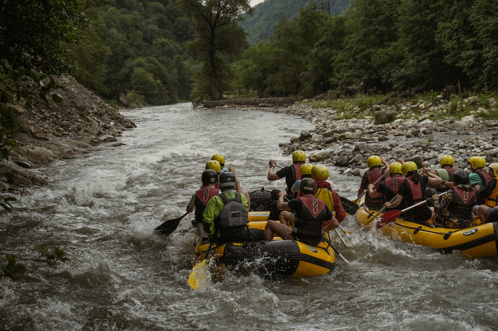
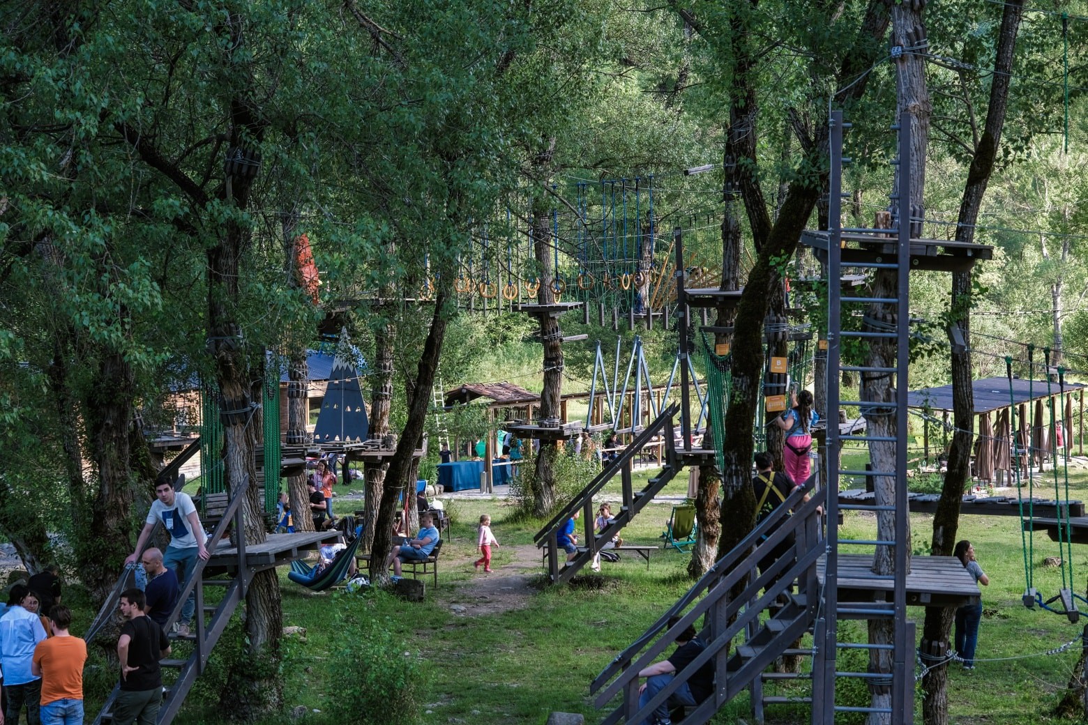
Mountaineering Routes & Maps to Georgia

Foreword

Global warming process is most obvious in the high mountains. Where once the glacier tongues were laid, now the bare moraines or even the swaying grasses can be observed. Glaciers, that were quite simple to pass 30-40 years ago, became very dangerous and in some cases are even impassable nowadays. Accordingly, the existing climbing routes and, more importantly, the access roads to such routes have significantly changed.

The routes offered, are described on basis of ascensions that took place in 2009-2011, and the GPS measurements were taken at the same time. The repeated ascension was impossible only to Shkhara Summit – due to a heavy meteorological conditions – and therefore, description of this route is based on the data provided by the expedition of 1990-ies.

We would like to express our sincere gratitude to all those mountain climbers who helped in developing the route descriptions or provided the respective photos.


Tetnuldi Massif

Tetnuldi is one of the most beautiful summits of Svaneti. Its snowy cone overlooks Mestia and attracts the travelers.
It has several routes of the most hard category. Hereunder you will find the description of easiest of them. The route starts at the picturesque slopes of Adishi Village and attracts tourists with the fascinating views and technical simplicity. It is planned to develop the mountain skiing resort in this area. Hence, the vicinities of Tetnuldi will become easier to access and better known.

TETNULDI: VIA SOUTHWETERN RIDGE (1-A; UIAA)
Ascending can be commenced at: a) Adishi Village; b) Ughviri Pass.

  • (a) From Adishi Village by the grassy slopes we head to the north. In 3-4
    hours we reach moraines, bypass them from the left and in 1-2 hours we
    get to the first overnight stop: CAMP-1  3013 m. It is very convenient camping
    place: grassy place on a hill, with the spring at its foot. Here a) and b) routes
    merge.
  • (b) From Ughviri Pass we turn to the west (do not continue to Ushguli). It
    is also possible to get to the Hut HUT-1  2786 m. by car. Trip from Mestia to the
    Hut by car takes 2 hours. It is 5-6 hours walking from Ughviri Pass. From the
    Hut we continue by the horse-riding path and in 1 hour reach CAMP-1 3013 m.
    It is recommended to stay overnight here.

From CAMP-1 3013 m. we head to the northwest, go by moraine and reach the simple snow couloir (inclination – 2025 degrees). We pass the couloir and step on the ridge. There are several overnight stop points at the ridge; this place is called Amarati Nest (3400 m.). It is the 2 hours walking CAMP-2 3715 m. Photo 3 – Way to upper plateau of Kasebi Glacier distance from CAMP-1 3013 m. At the ridge we turn left (to the north) and continue our way.

At the snow slopes of the medium complexity we try to avoid the rocks to the extent possible, or climb over the simple rocks, get to the snow slope, which we partly traverse and get to the upper plateau of Kasebi Glacier, at the edge of which we find the overnight stop CAMP-2 3715 m. (3-4 hours walking from Amarati Nest).

From CAMP-2 3715 m. we head towards northwest and cross the upper plateau of Kasebi Glacier. From its extreme left edge we ascend to the snow cornise. We continue along snow-ice cornise and get to the ridge. At the beginning of the ridge there is the cozy CAMP-3 4293 m. which can be used as a reserve overnight stop place. It takes 4-5 hours of walking to get here from CAMP-2 3715 m.

Descent – the same route, 5-6 hours to CAMP-2 3715 m.

Ushba Plateau Massif

Ushba Plateau is one of the most interesting mountain climbing regions of Central Caucasus. It is surrounded by such important alpinist summits, as Northern Ushba, Khorkha (Smaller) Ushba, Chatyn, Shchurovski, Shkhelda. Each of them comprises tens of the highest category routes. Here we describe the simplest of them. Getting to Ushba Plateau itself is quite interesting adventure indeed, since, due to global warming, upper part of Ushba Glacier became quite cracked and difficult to pass.

Way to Ushba Plateau commences at border guards’ hut (6 km from Mazeri Village) and, passing Becho Waterfalls, heads to the Hunters Overnight Stops CAMP-1 2367 m. To this point the way is well known and marked. The overnight stop is located at the top of the most beautiful Becho Waterfall. The middle of the waterfall (2077 m.) can be reached by horse. Few years ago the tongue of Ushba Glacier almost reached the overnight stop, however, nowadays it has backed for quite a distance.

From the Hunters’ Overnight Stop we get to moraine and walk along it. In 1-2 hours we get to the glacier. The glacier turns to north. (Photo-2)

While ascending up the glacier, we shall position ourselves on its left side (in the direction of walking) Photo-3. Here on, through the snow and crushed stone slope we shall get over the edge bulwark; Here we can find several excellent camping places.

From the rock bulwark we shall continue in the direction of glacier. This segment of Ushba Glacier is extremely fragmented; therefore, we shall move with caution and try to avoid the cracks. In 2-3 hours we will reach the upper plateau of Ushba Glacier, which ends with Shkhelda Crossing. At the left edge of the plateau there are overnight stop places.

From the upper plateau of Ushba Glacier we continue towards south, across the cracked slope covered with snow. In 1-1.5 hours we reach Ushba Plateau CAMP-3 4070 m.

PIK SHCHUROVSKY (1-B; UIAA)

From CAMP-3 4070 m. we go by southern ridge to Shchurovski Pik, cross Ushba Plateau (cracks), follow the simple snow ridge (cornises). Cross simple eroded rocks, then again by the snow ridge we approach the pre-summit elevation, and through the eroded rocks climb up the summit. It 3 hours from CAMP-3 4070 m.

From the Hunters’ Overnight Stop we get to moraine and walk along it. In 1-2 hours we get to the glacier. The glacier turns to north. (Photo-2)

CHATYN: BY WEST RIDGE (3-A; UIAA)

From CAMP-3 4070 m. we head towards Chatyn, cross Ushba Plateau (cracks) and get on the snow ridge. Climb up the ridge (cornices) and get to the western summit of Chatyn. By the snow-ice ridge we descend to the saddle (35-40 m). From the saddle by the medium difficulty eroded rock ridge we get to the main summit of Chatyn 350-400 m.

LITTLE USHBA: BY WESTERN RIDGE (2-B; UIAA)

From CAMP-3 4070 m. we head towards little Ushba and get to wide couloir, pass the bergschrund from the left, go along the left edge of the couloir, turn to the left and by the medium difficulty rocks follow the western counterfort for 100-120 m. Then pass to the northwestern ridge, turn to the right and by 30-40-meter medium difficulty rocks reach the summit. It takes 3-4 hours from Ushba Plateau.

NORTH USHBA: BY NORTHEAST RIDGE (4-A; UIAA)

From CAMP-3 4070 m. we head towards Northern Ushba, follow the medium inclination snow-ice slope, pass the bergschrund from the right, and by the snow-ice slope ascend to the Northern Ushba pad. By the wide ridge of the pad we get to the steep northeastern slope of 200-250 m, which leads us to the rocky skull (Nastenko Rocks). We follow 100-150 m by the simple eroded rocks. Then get to snow-ice steep slope of 350-400 m, which leads us the northeastern ridge directed towards summit. We follow ridge (walls); en route to Northern Ushba Summit we will meet three ascending/descending points. The entire route from CAMP-3 4070 m. to summit takes 10-11 hours.

Southern Ushba Massif

Southern Ushba area comprises Guli Glacier and the surrounding routes. From this place many Interesting routes commence towards both Southern Ushba and Northern Ushba summits. Here is also Gulba Summit with several simple routes leading to it, which makes this mountain interesting for both beginner and medium level mountain climbers.

SOUTH USHBA: BY SOUTHEASTERN COUNTERFORT. (GABRIEL) (5-B; UIAA)

From the church of abandoned Guli Village we head towards the farms, then by grassy slope we follow the left bank of Gulitskali River, in 2-3 hours cross the river and get to the overnight base at the foot of moraine. CAMP-1 2900 m.

From CAMP-1 2900 m. we go to moraine and enter into the western snow couloir (danger of stone fall). We do not follow couloir to the end – in 300-400 m we turn to the right and get to the stony platform, from which we traverse to the east, before we reach the ridge (reserve overnight stop). We follow the ridge towards the summit and get to the board (danger of stone fall). From here we turn to the left by 20-25 degrees and enter the snow-rock couloir, which is divided into the terraces with the simple vertical walls (hard- 4a) (danger of stone fall). The couloir leads us to the slope, where we can observe the remainders of old tent (reserve overnight stop). From here we follow the ridge to the north and get to the bulwark of 50 m height (hard – 4b).
CAMP-2 4180 m. is on the top of this bulwark. (Photo 2, Photo 4).

From CAMP-2 4180 m. in the direction of summit, in 30 meters the vertical wall of 50 meters height stands (hard 5b) (Fig. 3). On the top of the wall we get to little platform and turning to the left by 20-25 degrees enter the snow-rock couloir (Inclination 60-70 degrees), from which, passing the little saddle, we get to the ridge. 400-500 meters long ridge (hard 3A) leads us to the summit. The ridge is divided into the terraces, at one of which we can observe the memorial plate. Photo 4.

Shkhara Massif

Shkhara massif is the highest mountain area in Georgia. Here the highestsummit of georgia – Shkhara (5203 m) – is located.
The massif stands as a wall on the way of the visitors, and because of this it is called “pitsrula” (paling). It is extremely interesting for the mountain climbers, since it comprises many routes of the highest difficulty. The vertical fall on the routes is so big that Shkhara is frequently compared to the Pamir and Himalayan summits. Below you can find the description of one of the first and the most logical routes. It bears the name of legendary Svanetian mountain climber Gabriel Khergiani.

SHKHARA MTAVARI: BY RIGHT COUNTERFORT OF SOUTHEASTERN SLOPE
(BEKNU) (5-B; UIAA)

From the Jibiani Village (2100 m.) (Ushguli) we follow the road towards the Shkhara Glacier.

We step on the glacier from the left and get to the steep snow-ice slope, from which we reach the right counterfort of the lower rocky belt. We pass the waterfall from the right and get to the ledge by 180-200 m height rocks of the higher then medium difficulty. After this, in about 8-10 hours from departing CAMP-1 2280 m.we continue ascending to the right and by the medium difficulty snow rocks (height – 250-300 m.) get to the camping place – CAMP-2 3680 m.

From CAMP-2 3680 m. we turn to the right and by the snow rocks of counterfort we get to the rock triangle, which we bypass from the right and follow to the couloir. We traverse the couloir to the right and continue for 250-300 by difficult frosted rocks, ice slopes and hanging rocks. Following this, we go by medium and high difficulty snow rocks till we reach 100-200 m long snowice ridge. There is a camping place at the ridge – CAMP-3 4200 m. It takes 8-10 hours to get from CAMP-2 3680 m. to CAMP-3 4200 m.

From CAMP-3 4200 m. the higher then medium difficulty rocks of 400-600 m height lead us to 100-120 m long snow-ice ridge. Here, at 6-8 hours climbing distance from the CAMP-3 4200 m. we can find camping place – CAMP-4 4720 m. 

From CAMP-4 4720 m. we shall climb 35-40 m high difficulty vertical wall, after which, by the higher then medium difficulty snow rocks and snow-ice slope, we get to the main ridge of Shkhara Massive. We follow this simple snow-ice ridge to the right and get to Shkhara Summit in about 10-12 hours after departing from CAMP-4 4720 m.

Zeskho-Ailama Massif

Zeskho mountaineering camp is located in Zeskho River magnificent gorge. Camp is in very convenient position on alpine meadows. In old time Zeskho camp was derived for beginner and moderate climbers. Aside from Zeskho is located Ailama massif. Ailama is quite difficult mountain with numerous of high grade climbing routes

The routes   and    starts form the Alilama ex –alpine camp. Other
routs starts from the Zesxo alpine camp.

CAMP-1 2200 m. (LAPHURI CAMP), AND CAMP-2 2635 m. (MARJANISHVILI CAMP) ASCEND.

From the Zeskho alpine Camp 1800m. path goes on the East. Follow the track of a river and after 4-km. you’ll reach CAMP-1 2200 m. (The Laphauri Camp), from here starts the routes  .

From the CAMP-1 follow the gorge of a river , which turns to the northeast after 1-km.On the top of waterfall pass on a small size fallen stone moraine and at the top is placed CAMP-2 2635 m. (Marjanishvili Camp).Here
starts the routes  .

PASSIS-MTA (3-A; UIAA) 

From the summit Pitnargini we pass to the Tskhenistskhali plateau. We go to the saddle by the simple stone slope. On the right of the saddle, we go along the narrow ridge. We pass few saddles by clinbing the small walls, We ascend to the plateau of the small summit. From the plateau by the simple stony wall ascend the summit.

MACHKHAPARA: BY NORTHEASTERN RIDGE (2-A; UIAA) 

From the Marjanishvili Camp (CAMP-2 2635m.) to the direction of Sharivtsek pass follow the fallen stone slope. On the right side from the pass enter the Phitnargini Glacier and go on moving to 200-300 m. distance. After that, try to find easer entrance on the mountain range( On the mountain range maybe other passes, because of snow and clefts.)
From here follow the path on the 500 m. distance to the direction of north-east. Pass on a small saddle and from here with the easer wall pass on the peak.
Descend: with the same route.

MARJANISHVILI: EAST RIDGE (2-A; UIAA) 

On the East of the overnight camp we head towards the grass slope, then stone slope (800 m). By the snowy and stony ridge on the right we go to the small icy plateau over the saddle. We come to small glacier with crevasses and pass the wide snowy couloir on the left (300 m). In the middle of the snowy couloir there is a rocky hill, like an island that we pass from the left then we traverse 50m from right and go up trought the wide couloir up to the ridge. We go along the stone simpe ridge up to the summit (300 m).From here follow the path on the 500 m. distance to the direction of north-east. Pass on a small saddle and from here with the easer wall pass on the peak. Descend: with the same route.

Descent: the same route.

ZESKHO MAIN: SOUTH (3-A; UIAA) 

From the Laphuri Camp to the Zeskho saddle direction follow and cross grassed slope and then fallen stone slope (800 m), then enter the Fitrang’s hard break down plateau(300 m). Turn on the left and follow several steped hills which are divided by the snow and clefts (400 m). After , that go to big plateau , from there turn on the left and try to find pass on the cleft to get in the bottom of the Main Zeskho. From here with the snow slope get on the Zeskho pillow (200 m), then pass on the snow range and follow the path to the peak.

Descent: the same route.

TETRI UTSNOBI (2-A; UIAA) 

From the camp to the Fitnargin pateau – 300-400m. We go to the Tetri Utsnobi from the Plateau to right –100-200m. At the edge of snow and rock, we enter the ridge – 300-400 m. We pass the small saddle. We ascend the summit from the ridge.

Way back: the same route.

TETRI UTSNOBI (3-A; UIAA) 

We head towards stony moraine from the camp 3, then to the center of crevasse of Whte Unknown. We go to the glacier to the deep point, which goes to the rocks (800-900 m). Then we go to the right, to the stip wide couloir to the saddle – 200 m. We continue on the right, pass the ridge and arrive to the stony balcony. We ascent to the summit trought the fractioned ridge – 100m.

Way back: the same route.

TETRI UTSNOBI – SHAVI UTSNOBI TRAVERSE (4-B; UIAA) 

The route commences with the Tetri Utsnobi route (2a) to the summit. We go down to the snowy simple ridge 1400-150 m. from the summit of Tetri Utsnobi. We descend 4-5 m. on the right and the snowy slope 50m. We come to the snowy saddle of Tetri Utsnobi and gendarme. We pass 20 m. on the snowy saddle and 10-15 m. of rocky wall. Then we follow the rocky ridge to the gendarme – 50 m. From gendarme – 120-150 m, We follow the simple snowy and icy ridge, 40m we descend on the Western ridge. We go to the saddle from the Tetri Utsnobi 4-5 hours, on the left with the snowy wall. With the easy snowy ridge we get to the West gendarme 80-90 m. With the easy saddle we go left to the main gendarme (7-9 hours walk from the Tetri Utsnobi ). We descend by the snowy wall 50m. Then we pass the major gendarme 40-50 m. Here we ascend 50-60 m on the ridge. We pass the snowy ridge 200-250m amd come to the East gendarme. We pass 200-250 m. again on the snowy ridge and two small gendarmes and arrive to the foot of the summit. Hrom here we go to the Shavi Utsnobi summit by the Eastern ridge 150-200 m.

Descend: Northern ridge, 3b Length: 6-7 hours from the camp to the Tetri Utsnobi Summit, from the Tetri Utsnobi summit to the Shavi Utsnobi 10-12 hours, descend 3-4 hours.

CAMP-3 2100M. ASCEND TO THE SHAVI UTSNOBI CAMP

From the Zeskho alpine camp (1800 m.) we return by the car road , after crossing the second bridge before entering the village Zeskho turn on the right and enter the gorge until Shavi Utsnobi stone moraine.

SHAVI UTSNOBI (4-A; UIAA) 

From the overnight CAMP 3 we head towards to the ridge (800-900 m). From the right side we enter the gendarme 100 m. We easily descend to the small saddle. Then we pass one more gendarme from the right and come to the small balcony. Through the fractioned rock we come to the ridge 70-80 m. We ascend to the summit by the stony ridge – 100 m.

Way back: the same route.

AILAMA SOUTH – WEST RIDGE (4-A; UIAA) 

We enter the upper plateau of Khoruldashi 400-500 m. We ascend from the left the wide snowy-icy ridge to the saddle between the small Ailama and gendarme. We walk 100-150 m. from the saddle to the gendarme. We pass 3 clifs to the gendarme 100-150 m. and reach the saddle. We go through the 60 m narrow saddle to the North ridge. We walk 100-150 m. on the narrow ridge. Then we pass 70-80 m. snow wall. And 700-800 m. up to the summit.

Way back: the same route.

AILAMA “JAFARIDZE ROUTE” (5-A; UIAA) 

We head towards the lower icy plateau from Khoruldashi 100-150 m. by the left ridge. Then we continue 50 m. left and come to the rocky balcony. From here, we take the narrow, fractioned ridge and small walls to get up to the central part of the summit – 1000-1200 m. We come out to the small snow balcony. On the left we come to the snowy, rocky walls – 100-150 m. We arrive to the small saddle where there is an overnight spot. We go to the ridge by some snowy and rocky steps. We follow the ridge 200-250 m. to the summit.

Mkinvartsveri Massif

Mkinvartsveri is one of the most beautiful summits of Georgia. By the origin it is extinct volcano, therefore its slopes are not steep. Mkinvartsveri is also most popular tourist summit in Georgia. Ascension to it is not difficult technically. Existence of Bethlemi Hut Hotel (former meteorological station) at the foot of the glacier makes ascension even easier and accessible for many amateur mountain climbers. That’s why the interest to it in the tourist circles becomes more vivid day by day. Summit can be conquered by several routes. Below you can find the most classical and safest option. There are two more beautiful and simple summits in the vicinity of Mkinvartsveri – Ortsveri and Spartaki.

MKINVARTSVERI FROM MAILI PLATEAU BY THE NORTH SLOPES
(2-B; UIAA)

The way to Bethlemi Hut begins at the neck adjacent to Gergetis Sameba and follows Sabertse Ridge, after which it crosses Chkheri River. We shall position ourselves to the right of Gergeti Glacier and follow the moraines. We cross the glacier and ascend to the hill, at which Bethlemi Hut – former meteorological station – is located.

The route to Mkinvartsveri begins at Bethlemi Hut; we head towards east, pass Tetri Jvari (white cross), cross the stone-covered plateau and reach Shavi Jvari (black cross). From Bethlemi Hut it takes about 1.5-2 hours. At this place it is recommended to rope to each other!

From Shavi Jvari we turn to the left (southeast), in order to avoid the threat of stone fall from Khmaura slopes impending on the right side. Here we get to the glacier, which gradually turns to the right (northwest), follow it and in about 2-3 hours get to Maili Plateau.

From Maili Plateau we turn to the east and traversing medium steepness slope get to the Mkinvartsveri saddle (2-3 hours from plateau) (cracks). We pass big bergschrund and get to the ice slope heading towards the summit (inclination – 20-30 degrees). We follow the left edge and make belaying at the rocky points. Passing snow-ice dome we get to the summit.

Chaukhi Massif

Chaukhi Mountains are located in Khevsureti province. Nearest village is Juta. Rocky mountains are erected from green alpine meadows. Mountaineering rotes are very close from Base camp. Here in very small massive climbers can find all kind of routes interesting as for beginners also for high professionals.

ASCEND TO CHAUKHI CAMP

Every route which are going to the Chaukhi Peak Massif strats from the one camp. The route the Chaukhi Peak Massif strats in the village Juta (2100 m). After passing the village and reach the camp Zeta. In the camp you can take a shower , food and stay at night. From the camp follow the river Chaukh, the track is marked good. After passing throw the grassed plateaus and slopes you’ll exit on the high plateau(CAMP-1 2250 m), on which edge is three big boulders (10 m). On these boulders there are stakes and here it is possible to train for the rock climbing. This plateau is great for camping.

COLUMN (ASATIANI SUMMIT FROM NORTH) (6-A; UIAA) 

Route commences with the wide angle, then narrows a bit and sometimes goes into cracks – 50 m. Continues with the wide angle and crack section – 50 m. To climb the clear plate 40-50 m. goes to the small platform. Continues: climb the plate 50 m. small platform again. Then: slightly on the left – the narrow crack and inside corner – 50 m. We traverse to the right 30 m. and 20 m. on the wall we go to the overnight spot. On the left from this point there is another wall emerges out slightly – 30-40 m. On the right of the wall with small cracks and we follow the cliff remote from the wall by 1 m – 40 m.

If we through down the rope, it will almost go down the the overnight
point. From the cliff, we head towards the rocky carnise, that we pass from the left side. We climb negative pitch wall , then the carnise and we arrive to the plate, where we find some friends and anchor – 50 m. We traverse on the right and then straight to the small platform – 50 m. From here we follow corner with cracks and we come to the bottom of the wide chimney – 50 m. We follow the left corner inside the wide chimney, you come out to the ridge – 50 m. We follow the ridge – 100 m. Go to the roof We go through the wide, snowy chimney. We traverse to the bottom of gendarmes and go the the ridge. We follow the ridge to the summit.

Way back – Route 4A of the Assatiani Summit.

CHELIDZE: JAVAKHISHVILI SUMMIT FROM NORTH (4-B; UIAA)

From the Chaukhi camp (CAMP-1) go to the South-east directions, follow the grassed hill and reach the saddle and from here move straight on the loosen slope 40 m, then pass on distance 40 m by the traverse at the top of the “Fireplace”.

Widely opened “Buxari” with the clefts-100 m. go to the saddle near the big stone. By the saddle reach to wall, which begins with the little cleft, spread on in the widely opened corner, in small “Fireplace” is the stone cork, pass on and from here by the gently traverse move on the left, go to the internal corner and after that on the fallen stone platform. At the qimsa and skate is the station on 50 m. and at the top of the station 10 m. passing through the “Fireplace” you’ll reach the big platform. From here turn on the left hand and move until skate- 50 m. there is a rope for the “traversing”. From here by the traverses moving on the left you’ll meet three “Fireplace”, all of them is passable and the second is easer. Second “Fireplace”-30 m. 50 m. “Fireplace” spreads on the fallen big platform.

Follow the clear wall in the peak direction 50 m. and go to the platform. Follow a peak 70-80 m. and begin to traverse platform with snow and stone. Traverse 100 m. and move widely fallen stone palce.70-80 m. widely laid fallen “” Fireplace” goes on the mountain range, which length is to the mountain peak.

Descend:From the peak Javakhishvili 3A route, duration: 8-9 hours.

SEREBRIAKOVI: JAVAKHISHVILI SUMMIT FROM NORTH (5-A; UIAA)

From the Chaukhi camp (CAMP-1) go to the South-east directions, follow the grassed hill and traverse 100m. get in the platform and go on 120 m Pass the big stone and with the sloping couloir ascend on the platform which is located at the bottom of the wall 50 m. From here straightly move to the rock plate by the cornice on the left side passing the cornice in the easiest point 50 m. Go to “Fireplace” bottom. After climbing 20 m.

in the “Fireplace” get expanded and arise into platform. Here the climb distance is 20 m. after that route pass on the fallen platform.5-6m. from the left follow the right direction of the wall and you’ll reach the platform-50m. Traverse 50 m. on the right From the narrow rock go to gently moved mountain range 20 m. on the left side and get in the wide “Fireplace”, which exit to the platform-20 m. Walk 100 m. on the fallen slope and make traverse 50 m. on the left side, from here pass the mountain range with the widely easer climbing “Firewall”, follow 100 m. to ward the mountain range and get on the peak.

Descend: From Javakhishvili peak with the 3A route duration: 9-10 hours.

JOKHADZE: JAVAKHISHVILI SUMMIT FROM NORTH (5-B; UIAA) 

From the Chaukhi camp (CAMP-1) go to the South-east directions, follow the simple half-grassed stepped hill and move to little platform where begins the wall. Gently from the platform the big cleft runs the wall on the left side, at the top og the wall is saddle and station made on the stakes.- 50 m.

again follow the left cleft and get in the bottom of cornice. The station can be made on the skate and side. Also there is the 3 m. rope at the bottom of cornice. From here by traverses follow right side of the cleft, which exits on a platform, from platform, after passing 5-10 m. platform there will be entrance at the bottom of a couloir. With 10-15 m. rocky desk is possible to get to the big platform, where is the station after 20 m. At the end of the 80 m. climbing mountain range is the red wall with the length 5m, which is more difficult.

After that there are 30-40 m. separate walls where you need to jump. The path goes to the side and where you have to descend on 10 m. until saddle.

Here is a small platform then you have to ascend the big stone; Go on the right thought the stone and the rock you’ll get to the side ,then return again on a small platform. From platform follow the cleft which passes stone and there is the station. From here gently on the right side follow a cleft and go to the bottom of cornice, where are many skates-40 m. Turn around the cornice from the right side, go to the rocky phile, then gently on the left again go to the platform after one rocky step. Platform continue until saddle, near big stone at the bottom of a wall. With 50 m. rocky desk you’ll reach the big platform. From the platform follow the simple mountain range to the peak direction 200-300 m.

Descend: From Javakhishvili peak with the 3A route duration: 12-14 hours.

ROUTES & BEGINS  JAVAKHISHVILI CIRCUS, 3200 M.

From the Chaukhi camp (CAMP-1) go to the South directions, go around the ”Gamoqanula” stone hill.Go to the South directions on the fallen slopes and exit to the Javakhishvili snowy circus, where starts many routes.

ILIAUNI: JAVAKHISHVILI SUMMIT FROM SOUTH (5-A; UIAA)

The route starts from the Javakhishvili circus with the fallen stone slopes get in at the bottom of the wall -100 m. with dismissed rock go to the small rocky side-100 m. traverse on the left – from the begin on the narrow platform, then on the narrow “Fireplace”-70 m. and exit to the platform. Go to the 50 m.

clear climbing wall with the difficulty – 4. Then on the 40 m. wall, which goes to the “Fireplace” and again on the wall. Make a 5 m. traverse on the right and then move on the little platform. From here with the fourth difficulty climbing path and wide corner on the 50 m. ascend on the little platform. Gently on the left pass the fourth difficulty climbing path – 50 m. make a traverse on the left side by 5 m. then pass 20 m. widely opened “Fireplace” then 40 m. mountain range and ascend to the peak.

Descend: From Javakhishvili peak with the 3A route duration: 6-7 hours.

JAVAKHSHVILI FROM SOUTH (3-A; UIAA)  

The route starts from the Javakhishvili circus, 300-400 m. after the fallen stone slope with snowy couloir rise up to the saddle. From the saddle get in the “Fireplace” on the left and go to the platform – 40 m. follow the platform -20 m. find mere easer pass on the left side of wall and follow rocky desk. After 40 m. is the station made up with pitons, move forward and go to the little platform.

There is the station on the side after 50 m. make a 20 m. traverse on the left and get in the wide couloir-50m. and move on the mountain range which continues to the peak.

Descend: With the same route. Duration: 6-7 hours.

LEONIDZE FROM SOUTH (4-B; UIAA)

The route starts from the Javakhishvili circus after widely dismissed couloir the path goes to the frozen and snowy slope. Exit to the saddle 300-400 m. near a big stone. On the right side from the saddle starts the wall with a phile , then continues to the little platform and the follow the narrow cleft with skates to the built station – 50 m. At the top of the station runs a small size cleft , after passing this cleft go to the left in the narrow “Fireplace” and the go to the big spread on platform, where is the station built on the skates. 5 m. On the right side from the platform goes in the simple “Fireplace”(50 m).

Make a traverse of 100 m. on the right side to the wide platform from the head of the “Fireplace”. In the opened “Fireplace” to the peak direction ascend on the mountain range. Move to the right side from the mountain range to the peak.(70-80 m.)

Descend: With the same route duration: 6-7 hours.

KAMERONI FROM SOUTH (3-A; UIAA)  

From the Javakhishvili circus by snowy culuare ascend to the saddle (400 m), from the saddle with third difficulty wall (30 m.) ascend a narrow rocky mountain range. At the same time move on the sharp narrow mountain range. (200 m).

Descend: With the same route. Duration:7-8 hours.

ASATIANI FROM SOUTH (4-A; UIAA)

From the Javakhishvili circus ascend by the snowy couloir to the saddle (400 m). From the saddle climb on the third difficulty wall (50 m.) on the right, the wall has cracks, sometimes you have to move on the simple climbing philes. There is the station made up with pitons. Make 2-3 m. traverse on the right and get in the wide “Fireplace”.

After 60 m. snowy and stone fallen “Fireplace” move on the less snowed saddle. At the end of wall side is built
the station. on the left from the saddle move 40 m. on the narrow dismissed “Fireplace”. Ascend the long narrow platform and here is the station made up from the pitons.

Make 20m traverse on the right to platform at the bottom of the little “Fireplace”. With the opened corner ”Fireplace” move on the mountain range. Follow the dismissed mountain range to the peak.

Descend: With the same route. Duration: 8-9 hours.

RCHEULISHVILI FROM NORTH (3-A; UIAA)

From the Javakhishvili circus at the same time move on the walking stone fallen and snowy couloir on the very left side at the bottom of wall. At the same time climb the third difficulty path without security to the small rocky couloirs. Again cross a couloirs gently on the right side and get on the small size balcony of the dismissed rock. From here to the direction of the peak are some “Fireplaces”, which are the same difficulty-4.

Descend : With RCHEULISHVILI 1B route. Duration : 6-7 hours.

TAKAISHVILI FROM NORTH (2-A; UIAA) 

From the Chaukhi camp (CAMP-1) go to the South directions. After 1km. turn right and snowy and get in the widely opened stone fallen couloir (400 m). After you meet two narrow couloirs and get in the wide rocky couloirs on the left. Move gently 50 m. on the left- in the simple climbing and stone fallen couloir. Go to yhe little platform. Move forward 50 m. and go to the simple climb internal dismissed wide corner couloir sand follow it to the saddle. On the right from the saddle go around the little Gendarme on the left and follow the dismissed mountain range to the peak (300 m).

Descend: With the same route. Duration: 5-6 hours.

TIKANADZE FROM NORTH (2-A; UIAA) 

From the Chaukhi camp (CAMP-1) on the grassed hill to the Sphinx stone. On the right side from the down by the grassed slope you can ascend the mountain range-100 m. Follow the mountain range to the end and when you get at the stone fallen move right side and go to the saddle -200 m. On the left side from the saddle follow the sharp mountain range with the drawn in ropes at the end of the peak (500 m).

This path in the same time is walking distance. At the end of the mountain range before peak is 50 m. gently dismissed 3A difficulty wall on which is the peak.

Descend: With the same route duration: 7-8 hours.