Kayakers Guide to Georgia
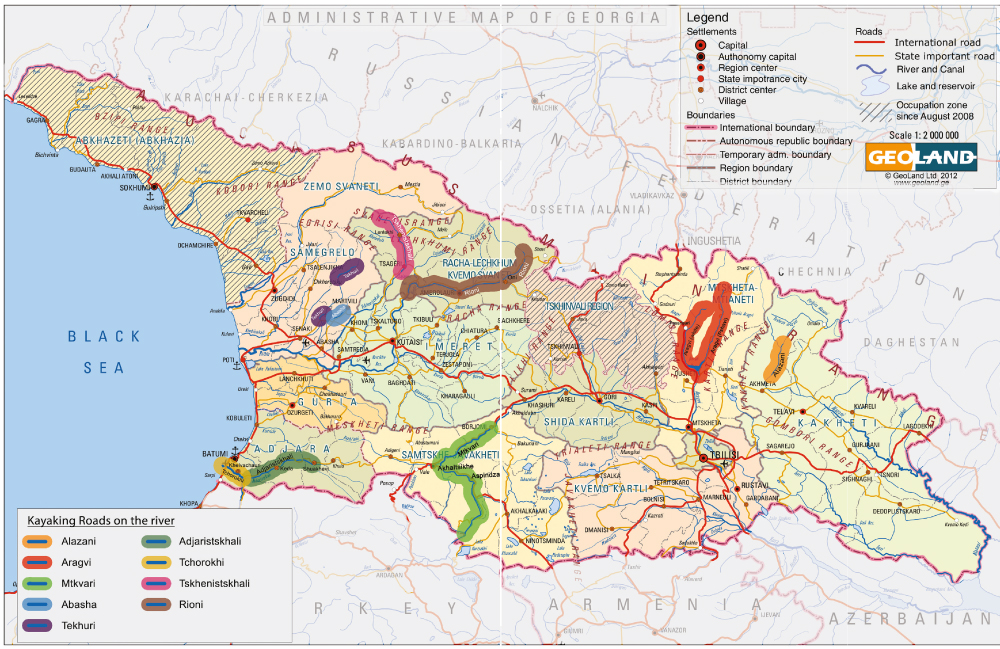
1) Aragvi river
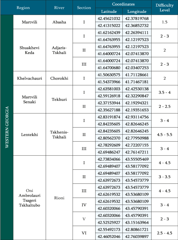
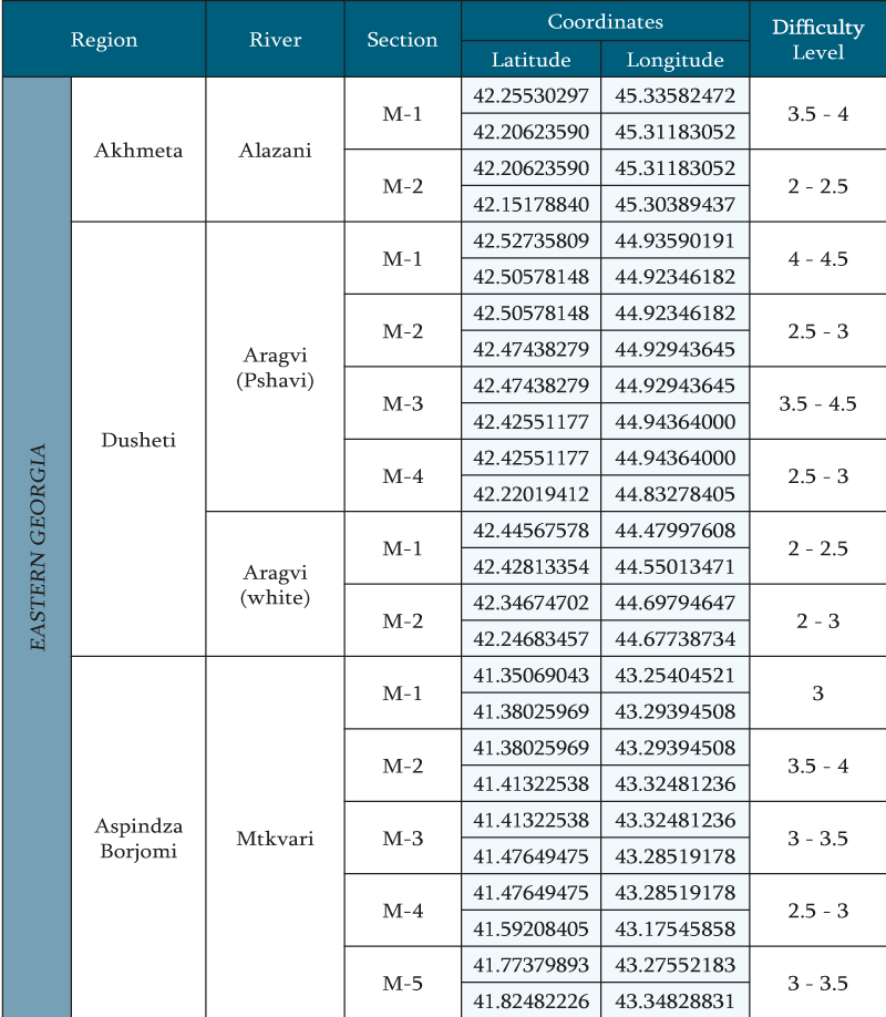
Aragvi – located in eastern Georgia , Kazbegi , Dusheti and Mtskheta municipalities. Its length is 112 km, the catchment area is 2724 km 2. Aragvi system of rivers made by – Mtiuleti (White) Aragvi , Gudamakari (Black) Aragvi , Khevsureti Aragvi and Pshavi Aragvi. The Main Aragvi starts in north – eastern part of volcanic mountains. Aragvi at upper and middle reaches is the mountain river, the lower section which flows at Mukhrani and Mtskheta plains apart. After it crosses the mountain range Skhaltba and Saguramo. Attached to the left side of the Mtkvari in Mtskheta .
Aragvi is fed by groundwater, rain and snow, as well as Glacier and eternal snow water
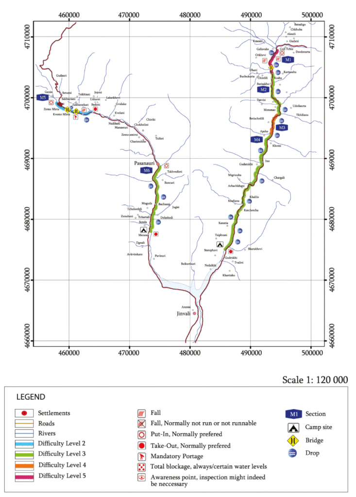
SECTION OF PSHAVI
Start begins in the valley of Barisakho, in the edge of the bridge. The river is divided into several sections.
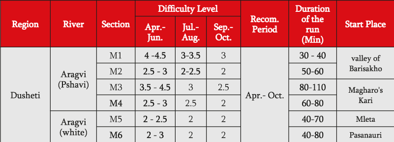
The first section (M1) is the most difficult one and is classified between 4-4.5 categories. As beginning this section is a waterfall to be seen, which height is 3 meters. The difficult part continues 5km along. It’s impossible to explore the river before descending, which increases the category of difficulty to the 5th category. There is some risks of being blocked by trees. This section ends as the valley ends, where is located a bridge. The next 5 kilometer the river flows in broad valley. (M2) The category of difficulty ranges between 2-2.5. In this section the river runs alongside the highway. After this section the valley is narrowed and the difficulty of the river increases to 3- 4.5. (M3) The inclination angle increases to, flow speed increases to 15-17 km/hour. There are huge stones and appropriately this section is characterized as high-technical. This place can be evaluated from the side, what decreases the risk of descending. The distance of the valley is defined as 4 km, after that before the finish there are no narrow valleys to be expected. The river flows relatively quietly, (M4) there are no huge stones on the way, the category of difficulty is qualified as 2-3, what enables starter and average level kayakers to descend in this section. Best place for camping is the territory near the finish place.
SECTION OF MLETA (M5)
Start place of descending – Mleta, from the lower side of the first turn of the highway. Allowed distance of the track is 12 km. Along the start to the finish runs the highway. This section of the river runs alongside the highway, which gives possibility to kayaker before starting to have a detailed look on the itinerary. The difficulty category of the river ranges between 2-2.5 categories. There are no especially difficult parts to pass. We have two bridges on the river, where boats should be moved manually during the itinerary. The river here is not full-flowing, along the track are many stones, the river is characterized as technical. To pass the river is possible for average level kayaker.
SECTION OF PASANAURI – MENESO (M6)
The start begins in Fasanauri, the length of the track is 15 km. to pass allowed distance is needed 1 hour and 15 minutes. The river is accompanied by the highway, which facilitates controlling the track.
There are some extra highways, with them it is possible to go to the shore of the river. There are no big stones in the river, which facilitates passing the track. The difficulty of the river ranges between 2- 3 categories. To pass the river is possible for average level kayaker.
Finish is in the village Meneso, where is possibility to camp.
2) Alazani river
Alazani is a river that flows through the Caucasus. It is the main tributary of the Kura in eastern Georgia, (Kakheti Region) and flows for 351 km. Part of its path forms the border between Georgia and Azerbaijan, before it meets the Kura (Mtkvari) at the Mingechaur Reservoir. The Alazani originates in the Greater Caucasus, south of the main ridge, in the northwestern part of the Akhmeta District. It flows initially to the south towards the town Akhmeta, then through the fruitful Alazani Valley of Kakheti towards the southeast. The Alazani is a river that flows through the Caucasus. River attached to Mingechauri reservoir (Azerbaijan). Before the reservoir build up Alazani was the main tributary of the Kura in eastern Georgia.
The Alazani dries up during the winter, but in the late spring, snow melt from the mountains swells the river enormously; this regularly causes flooding.
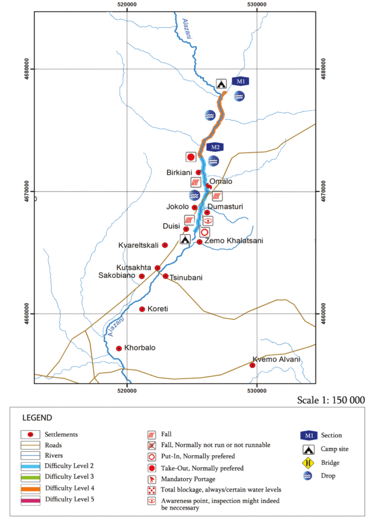
SECTION OF THE KHADORI WATERPOWER- DUISI
During the survey there was inspected only the mountain section of the river.
The first section (M1) is difficult and ranges between 3,5- 4 category.
The track starts by the beginning of the river Alazani, one kilometer above from the beginning of the second waterpower of Khadori. Altogether the river is not full-flow, but it is very fast and stony, technically difficult to pass. There are many huge stones, little waterfalls and stoppers. To view the river completely is possible except some places. From the start itself there is a woody place with many stones and comparatively less water, there are climbing places, approximately in one kilometer there is a waterpower, which blocks the river. Here is important to take the boat manually. The second river joins the waterpower and this river is also more full-flow. The second river of the waterpower flows in a comparatively large valley, which is not woody anymore. The river has a narrow riverbed and the water is fast. There are some huge stones, little waterfalls and stoppers. There were trees in the river, but this time it didn’t obstruct us. First section ends on top of the village Dzibakhevi.
The second section (M2) begins right there, which is easy and ranges between 2-2,5 category. The water
is fast, but there are no big stones and waterfalls anymore, but there are big waves and a pleasant getaway.
By the end of the track the riverbed gets larger and the river flows slower. The finish is by the village Duisi.
To the start and finish there is a road. The road runs from start to the end of the river, in some places it is
possible to go near to the riverbed by the car
3) Mtkvari river
Mtkvari, is a river in the Caucasus Mountains. Starting in northeastern Turkey, it flows through Turkey to Georgia, then to Azerbaijan, where it receives the Aras River as a right tributary, and enters the Caspian Sea. The total length of the river is 1,515 km.
SECTION OF VARDZIA-KHERTVISI
The start begins a few kilometers upwards Vardzia. From the start runs a highway. The whole river is divided into a few sections. First section (M1) extends about 4-5 kilometers. The highway runs along this section and is easily viewed. In the river, there are big stones, but they are easy to pass, there are waves and the category ranges between two and a half and three. Second section (M2) begins from farms; here the river flows in a narrow and high valley, which makes it difficult to explore the trace from the outside. Highway skips this section. This valley is the lower part of the castle of Tmogvi. In this part the speed of the river increases, there are many big stones, stoppers, huge waves, (M3) there is a possibility to stopping and over viewing previous sections. There are many technical sections. The category in the valley of Tmogvi ranges between three and a half and four categories. Third section begins as soon as one passes the valley and extends to 4-5 kilometers, where the river runs in relatively broad place, here are no big stones to be expected, but the flow is fast and wavy. The category ranges between three and three and a half. The fourth section (M4) is accompanied by the highway, which facilitates exploring the line. The finish is in the village Khertvisi.
SECTION OF KVABISKHEVI-LIKANI
The start begins from the village Qvabisxevi-Likani. (M5) From start to finish runs a highway. The length of the path is
14-15 kilometers. One hour and a half is required to pass the road. Along the river runs the highway, which makes easier to survey the trace. In 2 kilometers from the start, in village of Chitaxevi flows a river from the water power station and the river becomes abounding in water. There are no stones, but there are lots of waves. The category ranges between three and three and a half. The camp is located in the village of Chitakhevi alongside the river, where the highway runs.
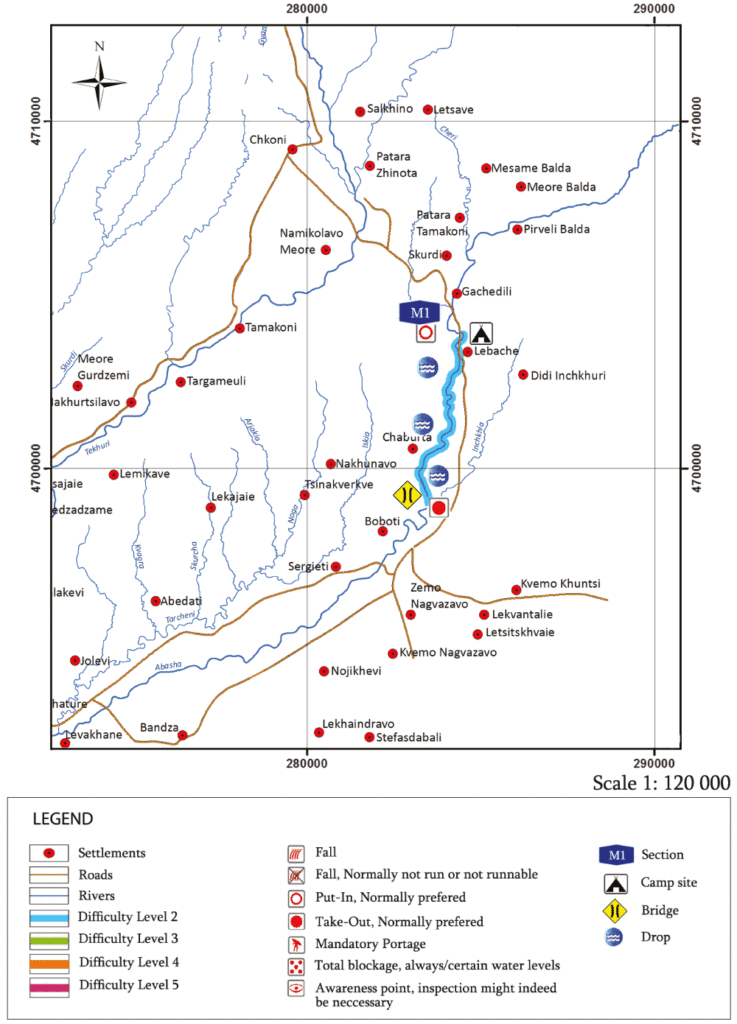
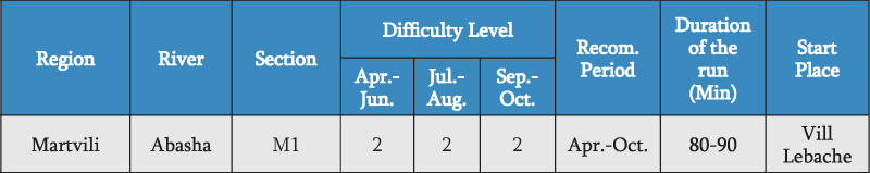
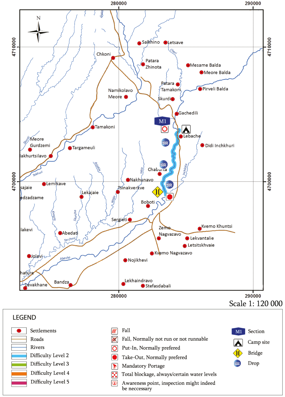
4) Abasha river
The Abasha also known as the Abashistskali is a river in north-western Georgia, running for 66 km in the municipalities of Martvili and Abasha, Samegrelo-Zemo Svaneti region. Its catchment area is 370 km2.
The Abasha river takes its origin through the confluence of the mountain streams Rachkhitskali and Toba, located near the village of Baldi, at 325 m above sea level, and meets the Tekhuri as its left tributary.
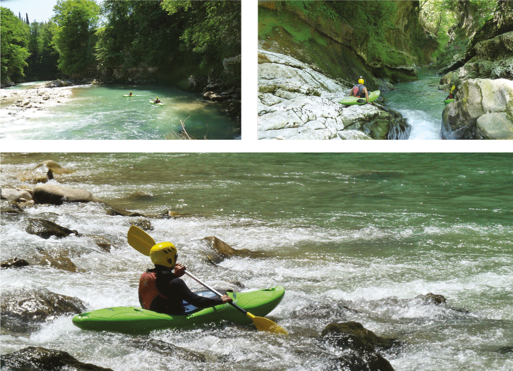
SECTION OF LEBACHE – BOBOTI (M1)
Start point of kayaking track is located near Oputskhole Canyon near Village Lebache. Road goes on the canyon, boat can be brought manually, using the path. It is not difficult to go to the water.
At first, the river flows in very beautiful and narrow canyon, we can find big boulders, but it’s easy to pass, river is very slow, in five hundred meters we can find a dam, which does not obstruct the pass, then we go out from canyon and river flows in a very wide riverbed, where it is necessary to bring boats manually, in the river the water is little. The finish is near the bridge of Village Boboti. The length of the track is not more than 5-6 kilometres, it is necessary more than an hour to pass the kayak section. The category of difficulty is 2.
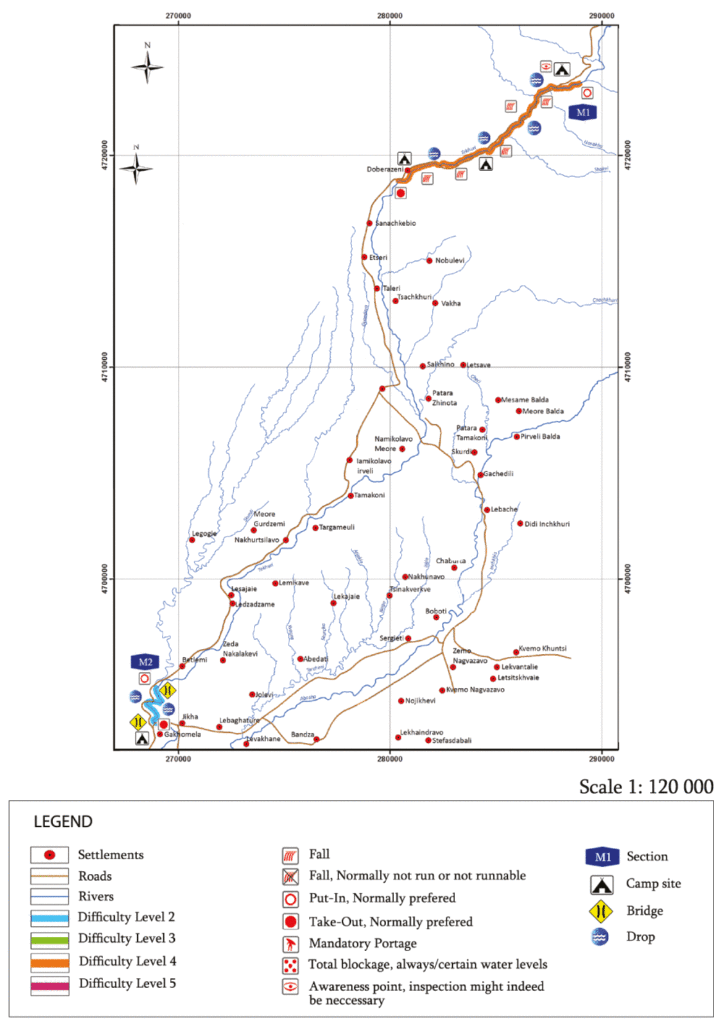
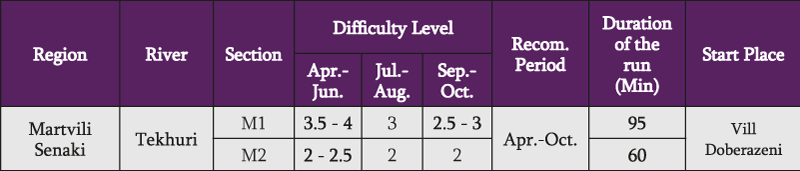
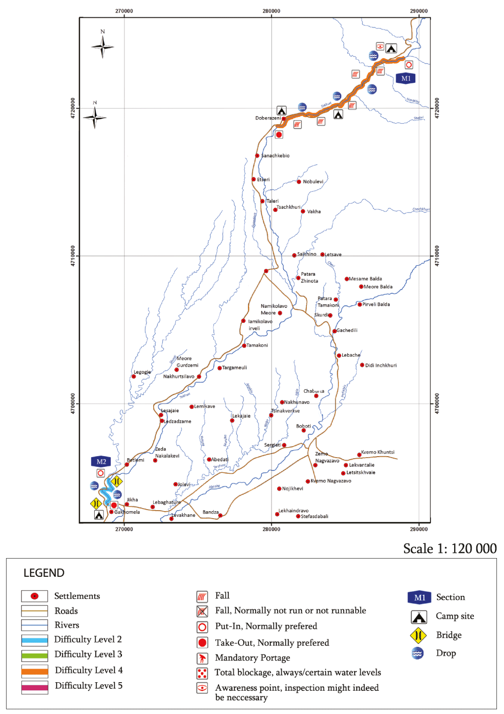
5) Tekhuri river
Tekhuri is a river in western Georgia (Martivli Senaki district and municipality). Starts in south slope of the ridge Egrisi at Tekhurishdud peak of 2400 meter from sea level. Attached to the right-hand side of the river Rioni. Length of Tekhuri is 108 km , the catchment area is 1040 km 2. A major tributary is river Abasha. Nourished by rain , snow and underground water. Flooding at the spring. The average annual consumption at Nokalakevi is 30.2 m3 / s. The resort Lebarde is located in the upper part of the valley.
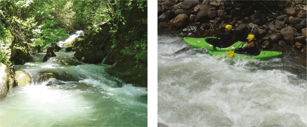
SECTION OF SALKHINO – DOBERAZENI (M1)
The start point located in the territory near of Lebarde road, there is an entrance in the forest which leads directly to the river, where it is possible to camp. The river is compound, there are many stones, rapids, stoppers, and little waterfalls, there are also some trees, but this time it didn’t obstruct, there is a narrow valley, there is a very fast water flow, but the river gives us a possibility to stop and view previous sections. Across the whole track runs road, but the great part of the river is impossible to view, because of the complexity of the valley. The river is very technical and category ranges between 3-4. In May the water will be higher and the difficulty will automatically increase too. The length of the track is about 8-10 kilometers and there is more than an hour and a half to pass with stop and explorations of the sections included. To pass the river is recommended only for experienced and professional kayakers.
SECTION OF BETLEMI – NOKALAKEVI – JIKHA (M2)
The start point located by the bridge in village Betlemi and the whole length of the track is about 5 kilometers long, it ends by the castle of Jikha. Whole section is beautiful valley, from the road it is impossible to view. The river is covered by trees and flows between high cliffs. Great part of the river flows in narrow riverbed, but it is not difficult to pass, category ranges between 2-2.5, there are waterfalls, but there are no big stones, stoppers and trees. From the start in about one kilometer and a half from the earth comes hot water of Sulfur. To pass the river is possible for beginner kayakers. It is necessary to have a guide, it is possible to plan a touristic route.
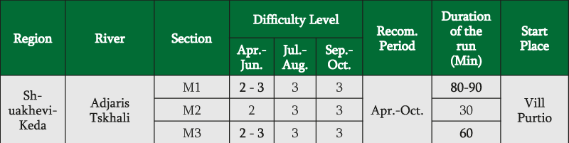
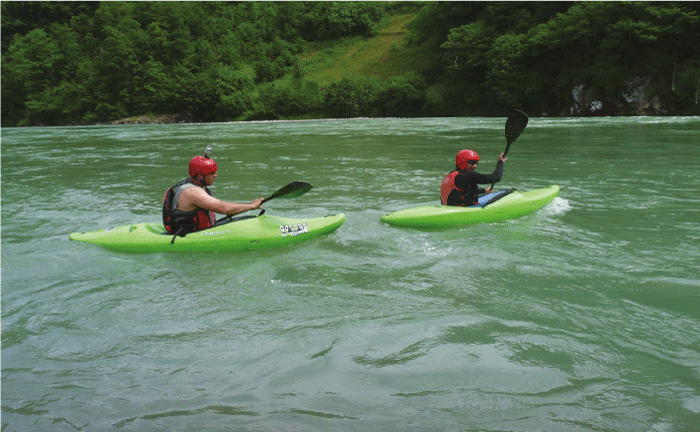
5) Adjaris Tskhali river
Adjaris Tskali is located in southwestern Georgia. in the territory of the Autonomous Republic of Adjara, Chorokhi right tributary, which flows into the Black Sea. It takes start at Arsiani ridge, flows through a narrow, deep gorge, widening at the estuary. Adjaristskali lengthis 90 km, with a catchment area – 1540 km². The river is fed by different sources, mainly from the rain waters. It is characterized by flooding throughout the year.
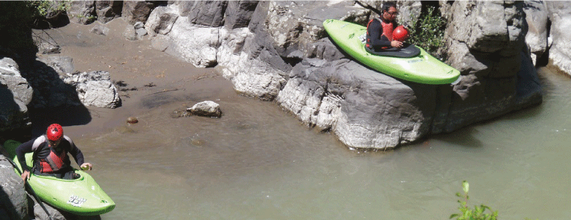
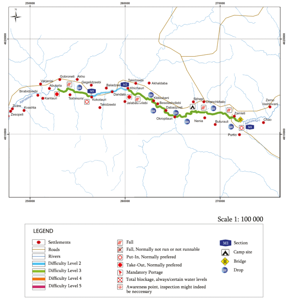
SECTION OF KHULO – SHUAKHEVI
The track starts from the bridge of Purtio. The river divides into few sections;
The first section (M1) is until Shuakhevi, 6-7 kilometers long, the road runs near the river but because of difficulties of the valley to view it is completely impossible. It took us 30-40 minutes to pass the first section. The category ranges between 2-3. The river is gradient and narrow, there are some stoppers, many big stones, and because of what there is much to climb and technically difficult parts.
In the second section (M2) the river flows in a wide valley.
In some parts of the river there are parted streams and the water becomes sparse, the length is approximately 8 kilometers, it needs almost one hour to pass. The road runs along the river and it is possible to view it. The category is not more than two.
In the third section (M3) there is a little canyon where the speed of the water gets faster, the water is technical, there are some huge stones, but the category ranges between 2-3. The length of the sections are 4-5 kilometers and we needed half of an hour to pass it. It is difficult to view this place. Along the whole track there are many spare ways which go directly to the river. This year winter in Adjara District was short, the sediment was little and there was practically no snow at all. This reduced the river full-flow very much. In normal occasion after winter there is completely different condition. The start of the track can be placed more above by the Berleti bridge (bridge of Tamar). Every riverbed will get higher minimum 1-1,5 of a difficulty category, in that case it will be necessary
to explore the whole river and to be armed with rescuers and rescue ropes on the shore.
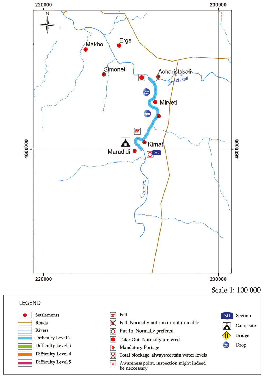
6) Chorokhi river
The river is located in Turkey and Georgia. Has led at Okus – Badadaghis mountains. The river length is 438 km , including 26 km on AAR (Adjara). Basin area is 22 thousand square kilometers, Chorokhi flowing tectonic ridges between the river valley and lazistan attached to the south of the city of Batumi on the Black Sea. Characterized by the spring – summer floods, is used for irrigation. The main tributaries: Adjaristskhali and Machakhelistskali .
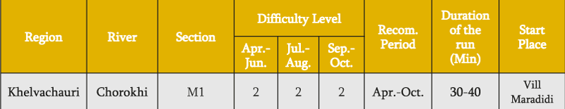
SECTION OF MARADIDI (M1)
The track starts by the village Maradidi by the Georgian-Turkish border. From start runs the road until the end of the track. The whole track is 5-6 kilometers long. The road runs alongside the river and it is easy to view the river.
The water is high and flows slowly, the category is – 2. It takes 30-40 minutes to pass the whole track. In this section of the river there is a construction work of two big water power plants, in the future it is planned to flood the whole section. There is one more big problem, by the Turkish side there is a water power plant which voluntarily locks the gateway of the water, that’s why it is impossible to know in advance if the water will get higher or lower, That is real dangerous for the kayaker, because of sudden flooding or sudden lowering of the water.
By talking with natives it was cleared that except of lowering and flooding there was water power plant cleaning work and the river took the trees, a lot of garbage, this is automatically dangerous. One positive side of this water power plant is that the river is clean and perfectly suited with valley beauty.
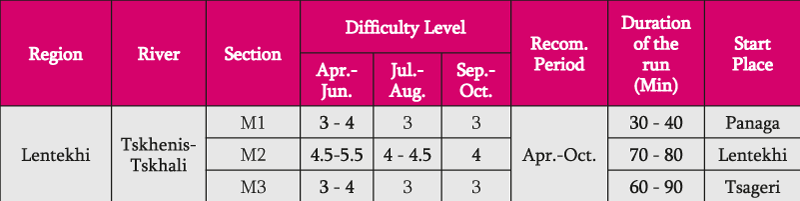
7) Tskhenistskhali river
Tskhenistskhali is a river in western Georgia. Its source is in the main range of the Caucasus Mountains, in the easternmost part of the Lentekhi District, lower Svaneti. A tributary of the river Rioni, its length is 184 km.[1] It flows through the small towns Lentekhi and Tsageri and joins the Rioni near the town Samtredia. Length of the river is 176 km. Fed by snow, rain, glacier and ground water. Spring – summer is characterized by a flood (annual runoff flows 70%), the winter – low-flow (10%), fall – floods (20%)
SECTION OF FANAGA-TSAGERI (M1)
The track starts from the village Fanaga. There is a road to the start place.
First section (M1) continues along 8 -10km. The road runs along the river, but there are some places, where is difficult to view the river from above. The river is full-flow, runs in wider places, there are also a few narrow valleys and the riverbed gets narrower, but it doesn’t complicate the passing. The river is fast, there are huge stones, but it’s easy to pass, there are waves and stoppers. The category ranges between 3-4. There were trees in the river, but in this section it didn’t matter. The river gave a possibility to go through. To pass this section we needed 30-40 minutes.
The second section (M2) is very difficult and begins with a narrow valley and continues 5-6 km, the road runs alongside and gives a chance to explore the track, which is essential before passing. The category ranges between 4 – 5. Tilt angel is big, there are many huge stones and many little waterfalls, many stoppers, many big waves and everything what should be in the 5th category river. By falling there is essential to have helpers with rescue ropes on the river shore. Where this difficult section finishes there is the river blocked up, there is impossible to pass along, the kayak must be taken out manually.
Third section (M3) starts from Lentekhi, where two rivers are joining and Tskhenistskhali becomes fullflow, the length of the track is about 15-20 km , runs along the road and the whole track is easy to view.
The track finishes in Tsageri. Here is the river wider, but fast. There are no big stones, but there are big waves and stoppers. The category ranges between 3-4. It needs one and a half hour to pass this section.
8) Rioni river
Rioni – Most of the rivers, which flows through the territory of Georgia. Length of 327 km, basin area of 13400 km². Starts at the south slope of the Pasi mountain, at an altitude of 2960 m. Attached to the Black Sea in the city of Poti. Rioni main tributaries – right : sakaura , Lukhuni , Ritseula , Lajanuri , gubistsqali , Tskhenistskali, Tekhuri, Tsivi ; Left : Chanchakhi , gharula , Jejora , lekhidari , Kvirila, Khanistskali Sulori Kumuri, khevistsqali .
It is fed by glacier , snow, rain and underground water.
Floods in the spring – summer , which is caused by the seasonal snow and glacier melt and rain.
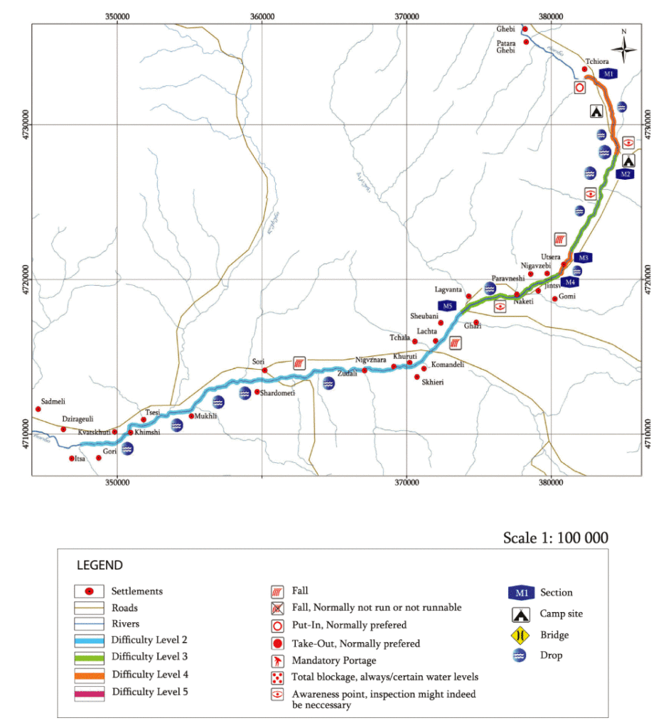
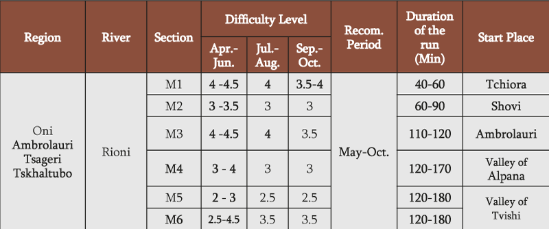
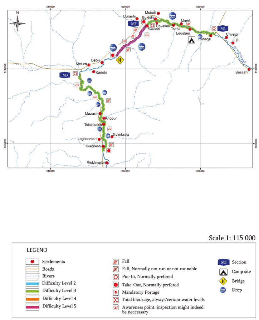
SECTION OF CHIORA – AMBROLAURI
The first section (M1) is the most difficult one and starts from village Chiora bridge, where the road goes. Approximately one km and a half the river flows very slowly, then begins the valley, the river-bed narrows and the river flows very fast. To view the first section from the road is almost impossible. The river was blocked up by the trees, there are many huge stones, big waves, stoppers, little waterfalls and fast flow. The category ranges between 4- 4.5. Before passing is essential to view whole section. There are some section, where the water doesn’t give a possibility to stop and view all sections passed before. The water is technically difficult to pass. There is almost no roads leading to the river from the difficulty of the valley itself.
The first section continues until the river Chanchakshi tributary at Shovi bridge and continues until the Utsera sour waters “Napertskala’’.
The second section: (M2) The river there is more full-flowing and loses its speed, but there are waves, and stoppers, the category ranges between 3-3.5. It is possible to view the section almost fully. There are a few roads leading to the river. This section wasn’t blocked up of trees so that we could pass it.
The third section (M3) is from Napertskala till the bridge of village Utsera. Here the river runs faster again, flows into narrow riverbed, there are many huge stones, big waves, stoppers, little waterfalls and fast flow. To view the whole section is very difficult, the section is very technical and the caregory ranges between 4-4.5.
The fourth section (M4) is the bridge of village Utsera and the village Gari. Here flows the river in a wider valley, there are no big stones, but there are lots of waves, stoppers and big waves, the category ranges between 3-4.
The fifth section (M5) is from village Ghari till Ambrolauri. To every section, by each start and finish goes a road.
SECTION OF ALPANA – THE BRIDGE OF DGHNORISI. SECTION (M6)
Start point located at the village Alpana, where is a good place for camping directly in front of the river.
The river flows in big valley and runs along the road. Almost the whole track is possible to view. The river is full-flow. There are no trees and big stones, there are waves and whirlpools. The category of the whole section ranges from 3-3.5 in addition to some places. Soon from the start by the bridge of Village Tvishi there is a difficult section, which continues approximately 300-400 meters and the category ranges between 4-4,5. Then the river slows down before the village Mekveni. In the upper section of the bridge Derchi, which is not to be seen from the valley itself, are big waves, whirlpools and the category ranges from 4-5 and the whole section continues until 400 meters. Then the river slows down again and until the finish there are no more difficult sections.